
Planning Commission is Reviewing New ‘Shaping the Avenue’ Draft, a Plan with Potentially Huge Implications
East Lansing’s Planning Commission held two meetings recently — about three hours, cumulatively, to date — entirely dedicated to reviewing a 66-page Shaping the Avenue plan.
Shaping the Avenue is partially derived out of the City’s master plan — “The Bigger Picture” — and, if passed by City Council, the Shaping the Avenue plan creates the Avenue Form District.
The Avenue Form District is a zoning district that would be created by City Council’s adoption of the Shaping the Avenue plan, which lays out a comprehensive form-based zoning code that would regulate developments in the Avenue Form District.
A form-based code, broadly, regulates development and projects based on their form — things like appearance, size, parking locations and so on — as opposed to regulating them based on their various uses. East Lansing’s current zoning code classifies districts by uses like commercial, residential, industrial and mixed-use. (More from ELi on form-based code.)
The regulations and requirements outlined in the plan, if adopted, will be incorporated into the zoning code and the form-based code outlined in the plan governs projects in the Avenue Form District.
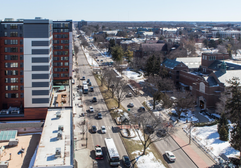
The currently proposed Avenue Form District encompasses downtown and significant portions of the Grand River corridor and parts of Michigan Avenue, as well as near-downtown parts of some residential neighborhoods. The entire proposed District is outlined in the “Regulating Plan” (below) included in the draft – essentially a map outlining the zoning within the proposed area.

The most recent draft, dated Nov. 17, 2020 (and available here), explains in the overview of the first section, “Purpose and Intent,” that the Avenue Form District is “designed to ensure that as this area of the City develops, it does so in accordance with the recommendations of the City’s Master Plan.”
Future developments in the Avenue Form District would need to follow the form-based code, but there does not appear to be any measure(s) requiring existing buildings that could become non-conforming to make any changes or modifications.
The overview in the “Purpose and Intent” section also lists six various purposes of having this form-based zoning district, that are achieved via the architectural and other standards laid out in the plan.
They are to develop a “fully integrated, mixed-use, pedestrian-oriented, and transit-supportive environment” with buildings containing multiple uses; to create a vibrant downtown for all, that “embraces the proximity and architectural design of our University neighbors” while maintaining a diversity of styles; to minimize the impact of cars, infrastructure costs, and environmental impacts; to regulate the height of buildings to create a smooth transition from the Avenue Form District to residential neighborhoods; to “inspire” redevelopment that increases and diversifies East Lansing’s housing and commercial spheres; and to create a simple, streamlined review process for development in the District.
East Lansing Planning and Zoning Administrator Darcy Schmitt outlined the timeline of the Shaping the Avenue plan at the beginning of the Planning Commission’s first work session meeting about it on Nov. 30.
A draft was produced in October 2018 based on East Lansing’s 2018 Master Plan and Zoning Code, Schmitt told the Planning Commission. That draft was then put out for review from the community. Simultaneously to the community offering input, a subcommittee of the Planning Commission was formed specifically to work on a new draft of the Shaping the Avenue plan.
The Shaping the Avenue subcommittee consisted of Planning Commission Chair Daniel Bollman, an architect by trade, Commissioners Chris Wolf and Cynthia Williams, and Schmitt representing City Staff.
After two years, that subcommittee has completed a draft, the one currently being reviewed by the Planning Commission. The Planning Commission is still set to review more of the 66-page draft plan. So far, through two meetings, it has reviewed six of the nine sections.
If adopted, under the form-based code in the Avenue Form District, a “great number” of existing properties are expected to have non-conforming structures. What does that mean?
Early in the discussion of the new draft, Bollman noted as much. He briefly explained this was due to the building setbacks — the distances between the exteriors walls and property lines — being moved back if the new plan is adopted.
“With the implementation of the form-based code,” Bollman said, “our expectation is that a great number of the existing properties that are located within the area that is going to be impacted are going to be considered non-conforming structures.”
There is no implication that anything will have to be done specifically to bring non-conforming structures that have already been built into conformance.
Instead, there are two pages in the draft plan that handle modifications to non-conforming structures. On page three is a form that includes directions for those wishing to modify an existing structure. It directs them to a table on page five.
The table on page five (below) delineates which parts of the modifications must comply with the form-based zoning standards regulating the Avenue Form District.

Basically, one categorizes their modification based on the type of modification (floor area, parking area, facade, use) and the degree or scale of the modification (i.e., the percent increase in parking area). Once someone knows what category their modification fits in, they can then see which standards in the form-based code the structure must comply with.
What has the full Planning Commission review entailed?
What the review process looks like has varied based on the first two work sessions. Some of the work is just looking for typos and clunky grammar as well as discovering terms missing definitions or having a redundant one.
Some edits and changes led to discussion, like a protracted moment examining whether the word “expansion” or “modification” was more apt in a chart defining the review process for different degrees of parking lot alteration.
And in both meetings so far members of the Planning Commission have been mindful that the ultimate purpose of this plan: To streamline and simplify a path for (re)development that also closely regulates the form of projects in the Avenue Form District.
“I don’t think we’re trying to make the review process longer for certain types of plans,” Wolf said during the “expansion” versus “modification” debate.
It is also worth noting, as ELi has previously reported in 2017, Shaping the Avenue involves multiple communities in the area (Lansing, East Lansing, Meridian Township, etc.) and CATA (the Capital Area Transportation Authority) to create “transit-oriented development” that was intended to integrate public transit.
Now, it appears the East Lansing is continuing on toward adopting a plan to create a new zoning district, governed by a form-based code.
Correction: A previous version of this story indicated East Lansing was the only local community proceeding with a form-based code. The City of Lansing is currently working on a form-based code. It has been updated to reflect that, and that the form-based code will be adopted as part of the zoning code, which was previously unclear.
Support ELi’s 2021 sustainability campaign to keep reporting like this coming in East Lansing. Act now:
